COVENTRY INDICATORS - ENVIRONMENTAL COVENTRY INDICATORS - ENVIRONMENTAL
Wildlife Habitats
 Wildlife
habitats are a very important part of our city’s assets, not only for protecting the
variety of wildlife but also for their educational and aesthetic value. This data was
taken from Warwickshire, Coventry and Solihull Habitat Biodiversity Audit which has been
recorded over three years from 1996. As this is the first year we have this data, it will
act as a base from which future trends of wildlife habitats can be measured. Wildlife
habitats are a very important part of our city’s assets, not only for protecting the
variety of wildlife but also for their educational and aesthetic value. This data was
taken from Warwickshire, Coventry and Solihull Habitat Biodiversity Audit which has been
recorded over three years from 1996. As this is the first year we have this data, it will
act as a base from which future trends of wildlife habitats can be measured.
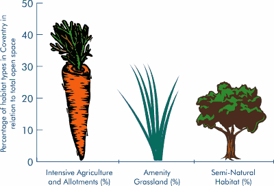
Habitat types were grouped together as
follows so they could be easily graphed and understood: ‘Intensive Agriculture and
Allotments’ includes arable land, improved grassland, as well as allotments. Amenity
Grasslands include playing fields and open grass spaces that are regularly mown and have
little or no wildlife value. ‘Semi-natural habitats’ include all the remaining
habitat types such as Scrub, Semi-Natural Woodland, Marsh Land.
Open Space makes up 39.4km2
(40%) of the city land area. Semi-natural habitats, which are of value to wildlife,
account for just a quarter of this compared to Amenity Grasslands, almost one third. This
means that land of value to wildlife makes up 9.88% of the total land area in the city and
this will be monitored to see whether it increases or decreases.
|